- Details
- Written by: Klaus Mayer
- Category: Panoramas-Victoria
- Hits: 9627
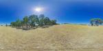
Panoramic views of the Grampians ranges with the ruins of an old farm cottage at Great Western Victoria, Australia.
Great Western is a small highway town in the Wimmera region, 225 kilometres north-west of Melbourne. European settlement of the area started with the arrival of graziers in the region until the Victorian gold rush drew thousands of people to the area. Today, Great Western is known for its many vineyards and wineries.
- Details
- Written by: Klaus Mayer
- Category: Panoramas-Victoria
- Hits: 10120
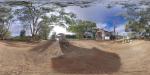
Panorama of the Millewa A Steam Pumping Station on the Murray River, Murray Sunset National Park, Victoria, Australia.
Millewa A Pumping Station is the last operational wood fired steam driven Victorian built pump on the Murray River. Situated at Lock 9 the pumping station can be reached via unsealed road from Lake Cullulleraine. The pumping station was constructed in 1927 and formed part of an irrigation system which supplied water to 462 soldier settler farms once a year. Water supply was limited to the winter months because 95% of the water evaporated in over 1,000 kilometres of open channels.
- Details
- Written by: Klaus Mayer
- Category: Panoramas-Victoria
- Hits: 9850
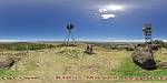
Panoramic views from Mount Rouse near Penshurst, Victoria, Australia. Mount Rouse is an extinct volcano on the outskirts of Penshurst. Mt Rouse offers uninterrupted views over the surrounding plains and towards the Grampians in the north, hence it is also site of one of the many fire towers in the bushfire prone state of Victoria.
Penshurst is a small town of about 500 people 275 km west of Melbourne, 31 km south-east of Hamilton, 50 km south-east of the Grampians. Penshurst is the centre of a large dairying, agricultural and pastoral district on a lava plain at the foot of extinct volcano Mt Rouse.
Before European settlement the Nareeb Nareeb and Kolor Aborigines occupied the area. Conflicts with white settlers and introduced diseases caused a rapid decline of the aboriginal population which could not be stopped by a reserve created around Mt Rouse in the 1840s.
Penshurst was laid out with very wide main streets to enable bullock trains to turn. Despite its declining population, Penshurst remains a tourist destination and an important service town to surrounding farms.
- Details
- Written by: Klaus Mayer
- Category: Panoramas-Victoria
- Hits: 10523
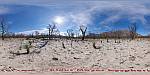
Panorama from the Roses Gap area in the Grampians National Park.
Panorama of the Roses Gap area recovering from bushfire 3 months after the 2014 Northern Grampians Complex fire. On 15 January 2014 seven fires were ignited by lightning across the Grampians NP. 3 of these fires combined and swept through the northern part of the Grampians NP and private property. One life was lost and approximately 52,000 hectares of land were burned along with thousands of sheep, wildlife and 10 houses in addition to sheds, cars and fencing.
Read more: Roses Gap after 2014 Northern Grampians Complex Fire, Grampians NP
- Details
- Written by: Klaus Mayer
- Category: Panoramas-Victoria
- Hits: 10057
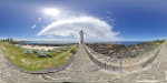
Panorama of Griffiths Island Lighthouse at historic Port Fairy on the Moyne River in Victoria.
The lighthouse made of bluestone was built in 1859 at the mouth of Moyne River on the eastern tip of an island which was then known as Rabbit Island.