- Details
- Written by: Klaus Mayer
- Category: Panoramas-Northern-Territory
- Hits: 7660
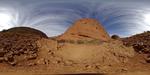
Panorama of Kata Tjuta aka The Olgas from Karu Lookout at the Valley of Winds Walking Track, Uluru - Kata Tjuta National Park, Northern Territory, Australia. Kata Tjuta are 36 steep sided rock domes which belong to the Uluru-Kata Tjuta National Park in the Red Centre of Australia. Kata Tjuta is a Pitjantjatjara word meaning 'many heads'.
- Details
- Written by: Klaus Mayer
- Category: Panoramas-Northern-Territory
- Hits: 10146
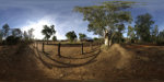
Panorama of the historic Telegraph Station in Alice Springs.
The Telegraph Station was built in the 1870s near a water hole on the Overland Telegraph Line to relay messages between Adelaide in the south and Darwin in the north of Australia. The Telegraph Station was the first building of the town Stuart which was renamed to Alice Springs in 1933. The historic building houses now a museum covering the history of European settlement in the Red Centre of Australia.
- Details
- Written by: Klaus Mayer
- Category: Panoramas-Northern-Territory
- Hits: 9978
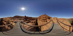
Panorama of Kings Canyon.
Watarrka National Park is located approximately 330kms southwest of Alice Springs. The Park comprises a total area of 722 sq km and encompasses the western end of the George Gill Range. The main natural features of the park are the rugged ranges, sandstone domes and outcrops, narrow gorges and rock holes.
- Details
- Written by: Klaus Mayer
- Category: Panoramas-Northern-Territory
- Hits: 10212
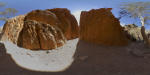
Panorama of Standley Chasm.
Standley Chasm is located 40km. west and 8km. north of Larapinta Road. It is now managed by representatives of Iwupataka, an aboriginal settlement on nearby Jay Creek, and is one of the most publicised attractions in Central Australia.
- Details
- Written by: Klaus Mayer
- Category: Panoramas-Northern-Territory
- Hits: 8474
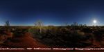
Panorama of sunset at Uluru aka Ayers Rock. The Uluru Kata Tjuta National Park is despite its increasing commercialisation a must see destination of many people's bucket list. While air travel provides a convenience alternative, only the long drive through the vast flat plains covered in red sand and small shrubs offers the feeling of excitement when Uluru appears on the horizon.
The unbelievable red colour of the sand and the location in the heart of Australia give this region the name Red Centre which will remain a must see destination for both locals and visitors.