photosphere
-
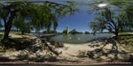
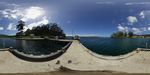
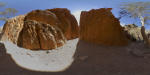
Moora Moora Creek Valley
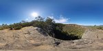
Panorama of rock formations lining Moora Moora Creek valley in the Grampians National Park.
-
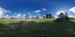
Mount Cole Reservoir
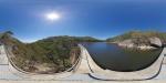
Panorama of Mount Cole Reservoir.
Panorama of Mount Cole Reservoir in the Mount Buangor state Park, Victoria, Australia. Mount Buangor State Park is a native bush reserve between Beaufort and Ararat. The reservoir is a great location for bird watching or a picnic but is only accessible with vehicles with good ground clearance.
-
Mount Wellington Summit Lookout
The 1271m high Mount Wellington offers spectacular panoramic views over Hobart, the Derwent river estuary, Bruny Island, Storm Bay and the Southwest National Park. The enclosed lookout offers protection from the rapidly changing weather which can change rapidly from sunshine to snow even in summer. The summit can be reached via walking tracks or a 22 kilometre long windy road from Hobart.
-
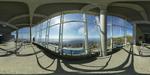
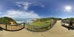
Murray's Boat Ramp, Booderee National Park
 Panorama of Murray's Boat Ramp in Booderee NP
Booderee means bay of plenty or plenty of fish in one of our languages, the Dhurgalanguage. Booderee is owned by the Wreck Bay Aboriginal Community. This scenic coastal National Park offers great beaches for water sports and plenty of fauna and flora for visitors who want to enjoy nature.
-
National Carillon on Aspen Island
Panorama of Lake Burley Griffin with the National Carillon
the National Carillon was a gift from the British Government to the people of Australia celebrating the 50th anniversary of the National Capital. Queen Elizabeth II officially opened the National Carillon on 26 April 1970. The carillon is a set of at least 53 cast and tuned bronze bells, played from a mechanical-action keyboard.
-
Old Telegraph Station, Alice Springs
Panorama of the historic Telegraph Station in Alice Springs.
The Telegraph Station was built in the 1870s near a water hole on the Overland Telegraph Line to relay messages between Adelaide in the south and Darwin in the north of Australia. The Telegraph Station was the first building of the town Stuart which was renamed to Alice Springs in 1933. The historic building houses now a museum covering the history of European settlement in the Red Centre of Australia.
-
One Tree Hotel, One Tree
 Panorama of One Tree Hotel at sunset.
One Tree Hotel was once an important watering stopover for cattle droves from the outback to the markets in the south. The locality One Tree was named after a single large tree which stood nearby at the time. While the respective tree no longer exists, others had been planted around the dams near the recently refurbished hotel.
-
Panoramas
The panoramas on this website are categorized by Australian states.
Please select a state below to view the panoramas available for each state.
-
Parliament House on Capital Hill
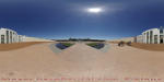
Panorama of Parliament House on Capital Hill
Parliament House is a focal point of Canberra which is built around capital hill. The building from 1988 was designed by architects Mitchell and Giurgola.
-
Port Arthur Historic Site
Panoramic view of Carnarvon Bay and Port Arthur Historic Site the largest historic penal station in Australia.
Port Arthur is located about 60 kilometres south-east of Hobart on the Tasman Peninsula on the shores of Carnarvon Bay.
The site was named after Lt Governor George Arthur and was the largest penal station in Australia between 1833 and 1877. -
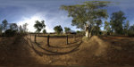
Railway Crossing near the Stuart Highway
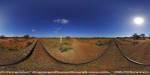
Panorama of a railway crossing in outback South Australia.
The railway crossing is south of Island Lagoon on the route of The Ghan which operates between Adelaide and Darwin. This area along Stuart Highway presents travellers with the typical vast plains of the outback covered in low shrubs and red earth.
-
Reed Lookout during Victoria Range Fire, Grampians NP
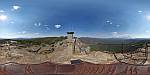
Panoramic view from Reed Lookout during Victoria Valley Complex Bushfire.
Reed lookout and fire tower offers uninterrupted views over the Serra Range, Victoria Valley, Victoria Range, Mount Difficult Range and Lake Wartook. At the time of this photo the Victoria Valley Complex Bushfire was burning an area of over 38,000 hectares on the western flanks of the Victoria Range.
-
Reed Lookout, Grampians NP
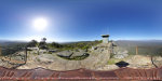
Panoramic views over Serra Range, Victoria Valley, Victoria Range, Lake Wartook and Mt Difficult Range from Reed Lookout. Due to the outstanding views over most of the Grampians National Park this location has also a Fire Tower to spot fires in one of the world's most bushfire prone regions.
-
Remarkable Rocks on KI
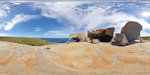
Panorama of Remarkable Rocks in Flinders Chase National Park on Kangaroo Island.
Remarkable Rocks are stunning rock formations sculpted by wind and sea on the far south-west coast of Kangaroo Island. The granite rocks are estimated to be about 500 million years old and sit precariously on a large granite outcrop above the roaring Southern Ocean.
-
Roses Gap after 2014 Northern Grampians Complex Fire, Grampians NP
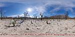
Panorama from the Roses Gap area in the Grampians National Park.
Panorama of the Roses Gap area recovering from bushfire 3 months after the 2014 Northern Grampians Complex fire. On 15 January 2014 seven fires were ignited by lightning across the Grampians NP. 3 of these fires combined and swept through the northern part of the Grampians NP and private property. One life was lost and approximately 52,000 hectares of land were burned along with thousands of sheep, wildlife and 10 houses in addition to sheds, cars and fencing.
-
Sheep Hills Silo Art
Panorama of enormous silo art mural by street artist Adnate in Sheep Hills, Victoria, Australia.
The mural depicts four indigenous faces, 2 elders, a boy and girl, on a starry background. Sheep Hills is located along the newly created silo art trail between Rupanyup and Patchewollock in the wheatbelt of Victoria.
-
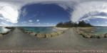
Split Point Lighthouse
Panorama of Split Point Lighthouse in Aireys Inlet.
Split Point lighthouse from 1891 is a marvelous example of the lighthouses along the Great Ocean Road. Beautiful beaches and natural scenery attract not only thousands of local and overseas tourists but also retirees and Australians looking for a sea-change. Aireys Inlet is a small coastal town approximately 120 kilometres south-west of Melbourne.
-
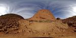
Standley Chasm, Northern Territory
Panorama of Standley Chasm.
Standley Chasm is located 40km. west and 8km. north of Larapinta Road. It is now managed by representatives of Iwupataka, an aboriginal settlement on nearby Jay Creek, and is one of the most publicised attractions in Central Australia.
-
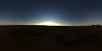
Sunset at Uluru
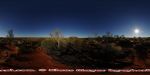
Panorama of sunset at Uluru aka Ayers Rock. The Uluru Kata Tjuta National Park is despite its increasing commercialisation a must see destination of many people's bucket list. While air travel provides a convenience alternative, only the long drive through the vast flat plains covered in red sand and small shrubs offers the feeling of excitement when Uluru appears on the horizon.
The unbelievable red colour of the sand and the location in the heart of Australia give this region the name Red Centre which will remain a must see destination for both locals and visitors.
-
Valley of the Winds, Kata Tjuta
Panorama of Kata Tjuta aka The Olgas from Karu Lookout at the Valley of Winds Walking Track, Uluru - Kata Tjuta National Park, Northern Territory, Australia. Kata Tjuta are 36 steep sided rock domes which belong to the Uluru-Kata Tjuta National Park in the Red Centre of Australia. Kata Tjuta is a Pitjantjatjara word meaning 'many heads'.